|
|
|||||||||||||||||
| Point ID: 8796 | Downloads | Plots | Site Data | Code: 12258 |
|
|
|||||||||||||||||
| Download | |
|---|---|
| Site Descriptor Information | Site Time Series Data |
| Link to all available data | |
| View: | Time Series | All |
| Units: | m3/s |
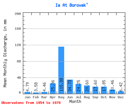
| Statistic | Jan | Feb | Mar | Apr | May | Jun | Jul | Aug | Sep | Oct | Nov | Dec | Annual |
|---|---|---|---|---|---|---|---|---|---|---|---|---|---|
| Mean | 4.79 | 3.60 | 4.46 | 25.36 | 115.86 | 34.73 | 24.25 | 20.60 | 17.60 | 17.85 | 10.47 | 6.42 | 300.96 |
| Standard Deviation | 1.76 | 1.31 | 1.76 | 20.13 | 59.89 | 21.58 | 20.18 | 22.17 | 15.17 | 13.67 | 4.86 | 2.55 | 102.09 |
| Min | 1.77 | 1.44 | 1.87 | 3.62 | 40.37 | 14.29 | 5.81 | 2.37 | 1.82 | 6.20 | 3.05 | 2.46 | 162.83 |
| Max | 7.19 | 6.01 | 7.78 | 72.52 | 203.80 | 92.25 | 62.62 | 93.53 | 58.03 | 49.42 | 18.30 | 10.44 | 476.31 |
| Coefficient of Variation | 0.37 | 0.36 | 0.40 | 0.79 | 0.52 | 0.62 | 0.83 | 1.08 | 0.86 | 0.77 | 0.46 | 0.40 | 0.34 |
 Return to R-Arctic Net Home Page