|
|
|||||||||||||||||
| Point ID: 879 | Downloads | Plots | Site Data | Code: 07FA006 |
|
|
|||||||||||||||||
| Download | |
|---|---|
| Site Descriptor Information | Site Time Series Data |
| Link to all available data | |
| View: | Time Series | All |
| Units: | m3/s |
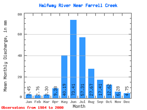
| Statistic | Jan | Feb | Mar | Apr | May | Jun | Jul | Aug | Sep | Oct | Nov | Dec | Annual |
|---|---|---|---|---|---|---|---|---|---|---|---|---|---|
| Mean | 3.45 | 2.78 | 3.30 | 9.38 | 40.19 | 73.41 | 57.30 | 27.66 | 17.41 | 12.62 | 6.29 | 4.75 | 257.63 |
| Standard Deviation | 0.78 | 0.50 | 0.90 | 4.43 | 17.12 | 33.92 | 35.78 | 22.91 | 9.64 | 5.94 | 1.74 | 0.97 | 77.88 |
| Min | 2.26 | 2.02 | 2.39 | 4.33 | 12.89 | 34.10 | 23.43 | 7.45 | 6.24 | 4.67 | 3.49 | 2.98 | 173.07 |
| Max | 4.96 | 3.60 | 5.81 | 18.13 | 68.45 | 161.90 | 171.56 | 89.08 | 34.93 | 31.51 | 9.84 | 6.30 | 474.02 |
| Coefficient of Variation | 0.23 | 0.18 | 0.27 | 0.47 | 0.43 | 0.46 | 0.62 | 0.83 | 0.55 | 0.47 | 0.28 | 0.20 | 0.30 |
 Return to R-Arctic Net Home Page