|
|
|||||||||||||||||
| Point ID: 8768 | Downloads | Plots | Site Data | Code: 12069 |
|
|
|||||||||||||||||
| Download | |
|---|---|
| Site Descriptor Information | Site Time Series Data |
| Link to all available data | |
| View: | Time Series | All |
| Units: | m3/s |
| Statistic | Jan | Feb | Mar | Apr | May | Jun | Jul | Aug | Sep | Oct | Nov | Dec | Annual |
|---|---|---|---|---|---|---|---|---|---|---|---|---|---|
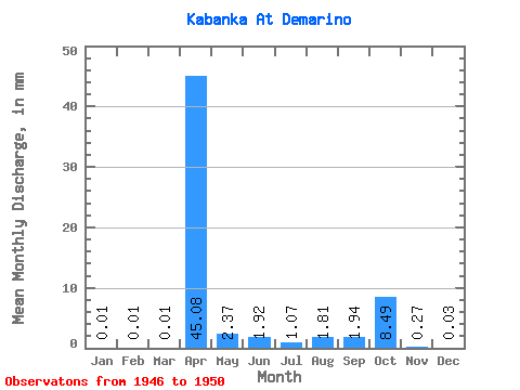
| Mean | 0.01 | 0.01 | 0.01 | 45.08 | 2.37 | 1.92 | 1.08 | 1.81 | 1.94 | 8.49 | 0.27 | 0.04 | 63.49 |
| Standard Deviation | 0.02 | 0.01 | 0.01 | 28.66 | 1.49 | 3.36 | 1.59 | 3.30 | 2.73 | 17.52 | 0.32 | 0.04 | 46.60 |
| Min | 0.00 | 0.00 | 0.00 | 13.02 | 0.56 | 0.11 | 0.03 | 0.01 | 0.01 | 0.02 | 0.02 | 0.00 | 14.83 |
| Max | 0.03 | 0.02 | 0.02 | 78.85 | 4.19 | 7.87 | 3.74 | 7.68 | 6.56 | 39.77 | 0.77 | 0.10 | 127.08 |
| Coefficient of Variation | 1.41 | 1.37 | 1.37 | 0.64 | 0.63 | 1.75 | 1.48 | 1.82 | 1.41 | 2.06 | 1.18 | 1.11 | 0.73 |
 Return to R-Arctic Net Home Page