|
|
|||||||||||||||||
| Point ID: 8767 | Downloads | Plots | Site Data | Code: 12064 |
|
|
|||||||||||||||||
| Download | |
|---|---|
| Site Descriptor Information | Site Time Series Data |
| Link to all available data | |
| View: | Time Series | All |
| Units: | m3/s |
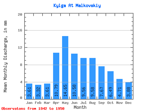
| Statistic | Jan | Feb | Mar | Apr | May | Jun | Jul | Aug | Sep | Oct | Nov | Dec | Annual |
|---|---|---|---|---|---|---|---|---|---|---|---|---|---|
| Mean | 3.61 | 3.35 | 3.61 | 10.79 | 14.65 | 10.58 | 9.56 | 9.58 | 7.67 | 6.49 | 4.71 | 3.87 | 104.96 |
| Standard Deviation | 5.47 | 4.89 | 5.57 | 7.72 | 10.73 | 7.07 | 6.69 | 9.27 | 7.47 | 6.40 | 4.83 | 4.27 | 57.62 |
| Min | 0.00 | 0.00 | 0.00 | 0.00 | 1.73 | 0.21 | 0.22 | 0.00 | 0.00 | 0.06 | 0.00 | 0.00 | 49.21 |
| Max | 15.12 | 13.63 | 15.75 | 22.57 | 34.66 | 20.58 | 21.42 | 23.00 | 16.62 | 12.92 | 10.37 | 9.77 | 201.58 |
| Coefficient of Variation | 1.52 | 1.46 | 1.54 | 0.71 | 0.73 | 0.67 | 0.70 | 0.97 | 0.97 | 0.99 | 1.03 | 1.10 | 0.55 |
 Return to R-Arctic Net Home Page