|
|
|||||||||||||||||
| Point ID: 8742 | Downloads | Plots | Site Data | Code: 12627 |
|
|
|||||||||||||||||
| Download | |
|---|---|
| Site Descriptor Information | Site Time Series Data |
| Link to all available data | |
| View: | Time Series | All |
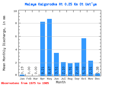
| Units: | m3/s |
| Statistic | Jan | Feb | Mar | Apr | May | Jun | Jul | Aug | Sep | Oct | Nov | Dec | Annual |
|---|---|---|---|---|---|---|---|---|---|---|---|---|---|
| Mean | 0.16 | 0.03 | 0.03 | 8.19 | 8.63 | 3.47 | 2.06 | 1.89 | 2.02 | 5.71 | 2.33 | 0.38 | 34.81 |
| Standard Deviation | 0.24 | 0.08 | 0.07 | 8.59 | 9.27 | 3.02 | 2.44 | 3.38 | 2.31 | 8.87 | 4.26 | 0.56 | 23.52 |
| Min | 0.00 | 0.00 | 0.00 | 0.00 | 0.00 | 0.00 | 0.00 | 0.00 | 0.00 | 0.00 | 0.00 | 0.00 | 3.28 |
| Max | 0.57 | 0.26 | 0.19 | 22.14 | 27.64 | 7.93 | 6.96 | 11.44 | 6.55 | 29.54 | 12.91 | 1.43 | 71.04 |
| Coefficient of Variation | 1.50 | 2.54 | 2.24 | 1.05 | 1.07 | 0.87 | 1.18 | 1.79 | 1.14 | 1.55 | 1.83 | 1.47 | 0.68 |
 Return to R-Arctic Net Home Page