|
|
|||||||||||||||||
| Point ID: 8741 | Downloads | Plots | Site Data | Code: 12626 |
|
|
|||||||||||||||||
| Download | |
|---|---|
| Site Descriptor Information | Site Time Series Data |
| Link to all available data | |
| View: | Time Series | All |
| Units: | m3/s |
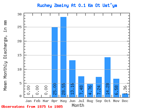
| Statistic | Jan | Feb | Mar | Apr | May | Jun | Jul | Aug | Sep | Oct | Nov | Dec | Annual |
|---|---|---|---|---|---|---|---|---|---|---|---|---|---|
| Mean | 0.26 | 0.00 | 0.00 | 24.86 | 28.25 | 13.37 | 7.79 | 4.61 | 7.33 | 14.26 | 6.79 | 1.48 | 108.73 |
| Standard Deviation | 0.60 | 0.00 | 0.00 | 36.10 | 28.36 | 12.59 | 9.30 | 5.98 | 10.06 | 22.83 | 10.69 | 2.75 | 83.60 |
| Min | 0.00 | 0.00 | 0.00 | 0.00 | 0.00 | 0.00 | 0.00 | 0.00 | 0.00 | 0.00 | 0.00 | 0.00 | 2.40 |
| Max | 1.77 | 0.00 | 0.00 | 98.68 | 74.77 | 31.58 | 23.79 | 14.95 | 27.63 | 74.77 | 28.29 | 8.16 | 226.29 |
| Coefficient of Variation | 2.30 | 1.45 | 1.00 | 0.94 | 1.20 | 1.30 | 1.37 | 1.60 | 1.57 | 1.85 | 0.77 |
 Return to R-Arctic Net Home Page