|
|
|||||||||||||||||
| Point ID: 8724 | Downloads | Plots | Site Data | Code: 12508 |
|
|
|||||||||||||||||
| Download | |
|---|---|
| Site Descriptor Information | Site Time Series Data |
| Link to all available data | |
| View: | Time Series | All |
| Units: | m3/s |
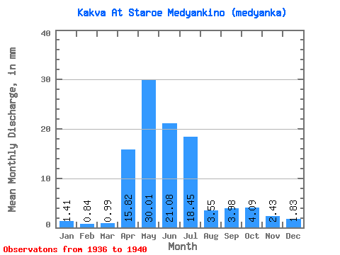
| Statistic | Jan | Feb | Mar | Apr | May | Jun | Jul | Aug | Sep | Oct | Nov | Dec | Annual |
|---|---|---|---|---|---|---|---|---|---|---|---|---|---|
| Mean | 1.41 | 0.84 | 0.99 | 15.82 | 30.00 | 21.08 | 18.45 | 3.54 | 3.98 | 4.08 | 2.43 | 1.83 | 100.40 |
| Standard Deviation | 0.97 | 0.81 | 0.89 | 4.18 | 8.99 | 14.00 | 16.83 | 0.72 | 3.28 | 3.74 | 2.18 | 1.60 | 1.89 |
| Min | 0.22 | 0.13 | 0.27 | 9.02 | 22.61 | 11.87 | 8.42 | 3.08 | 1.41 | 0.07 | 0.11 | 0.12 | 99.06 |
| Max | 2.66 | 2.06 | 2.38 | 19.23 | 44.92 | 41.95 | 43.62 | 4.62 | 8.25 | 7.80 | 5.20 | 3.28 | 101.74 |
| Coefficient of Variation | 0.69 | 0.96 | 0.90 | 0.26 | 0.30 | 0.66 | 0.91 | 0.20 | 0.82 | 0.92 | 0.90 | 0.87 | 0.02 |
 Return to R-Arctic Net Home Page