|
|
|||||||||||||||||
| Point ID: 8722 | Downloads | Plots | Site Data | Code: 12504 |
|
|
|||||||||||||||||
| Download | |
|---|---|
| Site Descriptor Information | Site Time Series Data |
| Link to all available data | |
| View: | Time Series | All |
| Units: | m3/s |
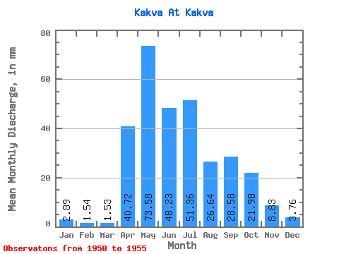
| Statistic | Jan | Feb | Mar | Apr | May | Jun | Jul | Aug | Sep | Oct | Nov | Dec | Annual |
|---|---|---|---|---|---|---|---|---|---|---|---|---|---|
| Mean | 2.89 | 1.56 | 1.53 | 40.72 | 73.56 | 48.23 | 51.36 | 26.64 | 28.58 | 21.98 | 8.83 | 3.76 | 303.28 |
| Standard Deviation | 1.44 | 0.89 | 0.79 | 21.41 | 28.64 | 25.16 | 67.76 | 27.10 | 38.07 | 7.30 | 4.29 | 0.12 | 171.77 |
| Min | 1.31 | 0.38 | 0.85 | 5.37 | 45.77 | 23.80 | 14.53 | 4.84 | 7.00 | 8.16 | 3.77 | 3.63 | 201.05 |
| Max | 5.31 | 2.86 | 3.02 | 63.39 | 126.60 | 95.43 | 187.95 | 78.15 | 105.80 | 28.48 | 15.51 | 3.90 | 608.94 |
| Coefficient of Variation | 0.50 | 0.57 | 0.52 | 0.53 | 0.39 | 0.52 | 1.32 | 1.02 | 1.33 | 0.33 | 0.49 | 0.03 | 0.57 |
 Return to R-Arctic Net Home Page