|
|
|||||||||||||||||
| Point ID: 872 | Downloads | Plots | Site Data | Code: 07EE010 |
|
|
|||||||||||||||||
| Download | |
|---|---|
| Site Descriptor Information | Site Time Series Data |
| Link to all available data | |
| View: | Time Series | All |
| Units: | m3/s |
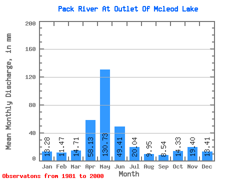
| Statistic | Jan | Feb | Mar | Apr | May | Jun | Jul | Aug | Sep | Oct | Nov | Dec | Annual |
|---|---|---|---|---|---|---|---|---|---|---|---|---|---|
| Mean | 13.27 | 11.56 | 14.71 | 58.13 | 130.71 | 49.41 | 20.04 | 9.95 | 8.54 | 14.33 | 19.40 | 13.41 | 362.48 |
| Standard Deviation | 5.05 | 3.33 | 6.30 | 23.31 | 26.92 | 22.95 | 8.88 | 4.54 | 4.90 | 8.33 | 12.57 | 3.30 | 63.83 |
| Min | 8.56 | 7.08 | 7.33 | 9.06 | 88.54 | 19.11 | 9.44 | 4.59 | 3.67 | 4.38 | 8.92 | 8.85 | 238.13 |
| Max | 24.89 | 18.85 | 36.22 | 101.85 | 202.48 | 93.42 | 44.85 | 18.51 | 24.73 | 30.63 | 62.73 | 19.89 | 495.57 |
| Coefficient of Variation | 0.38 | 0.29 | 0.43 | 0.40 | 0.21 | 0.47 | 0.44 | 0.46 | 0.57 | 0.58 | 0.65 | 0.25 | 0.18 |
 Return to R-Arctic Net Home Page