|
|
|||||||||||||||||
| Point ID: 8703 | Downloads | Plots | Site Data | Code: 11661 |
|
|
|||||||||||||||||
| Download | |
|---|---|
| Site Descriptor Information | Site Time Series Data |
| Link to all available data | |
| View: | Time Series | All |
| Units: | m3/s |
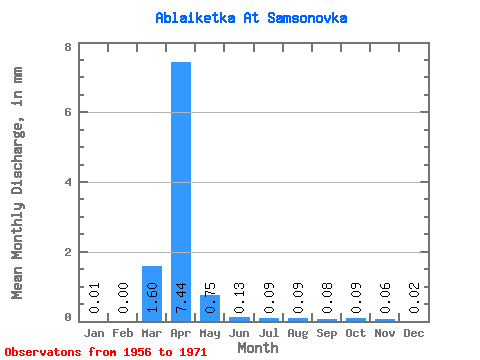
| Statistic | Jan | Feb | Mar | Apr | May | Jun | Jul | Aug | Sep | Oct | Nov | Dec | Annual |
|---|---|---|---|---|---|---|---|---|---|---|---|---|---|
| Mean | 0.01 | 0.00 | 1.60 | 7.45 | 0.75 | 0.13 | 0.09 | 0.09 | 0.08 | 0.09 | 0.06 | 0.02 | 7.68 |
| Standard Deviation | 0.03 | 0.01 | 3.23 | 10.01 | 1.61 | 0.13 | 0.06 | 0.07 | 0.06 | 0.06 | 0.04 | 0.02 | 9.29 |
| Min | 0.00 | 0.00 | 0.00 | 0.12 | 0.05 | 0.04 | 0.00 | 0.00 | 0.00 | 0.00 | 0.00 | 0.00 | 0.42 |
| Max | 0.10 | 0.05 | 9.21 | 34.34 | 6.29 | 0.52 | 0.20 | 0.25 | 0.23 | 0.23 | 0.16 | 0.07 | 26.37 |
| Coefficient of Variation | 2.31 | 3.61 | 2.02 | 1.34 | 2.15 | 0.99 | 0.64 | 0.76 | 0.69 | 0.63 | 0.71 | 1.20 | 1.21 |
 Return to R-Arctic Net Home Page