|
|
|||||||||||||||||
| Point ID: 8700 | Downloads | Plots | Site Data | Code: 11628 |
|
|
|||||||||||||||||
| Download | |
|---|---|
| Site Descriptor Information | Site Time Series Data |
| Link to all available data | |
| View: | Time Series | All |
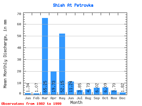
| Units: | m3/s |
| Statistic | Jan | Feb | Mar | Apr | May | Jun | Jul | Aug | Sep | Oct | Nov | Dec | Annual |
|---|---|---|---|---|---|---|---|---|---|---|---|---|---|
| Mean | 1.34 | 1.08 | 65.24 | 19.73 | 52.15 | 11.24 | 3.85 | 4.73 | 6.02 | 6.09 | 3.70 | 1.82 | 112.23 |
| Standard Deviation | 0.70 | 0.46 | 240.31 | 18.09 | 33.94 | 8.49 | 2.77 | 4.84 | 5.45 | 5.06 | 3.60 | 1.19 | 51.43 |
| Min | 0.52 | 0.47 | 0.54 | 0.00 | 7.40 | 1.59 | 0.83 | 0.77 | 0.76 | 1.06 | 0.87 | 0.65 | 18.35 |
| Max | 2.97 | 1.82 | 900.18 | 59.25 | 96.99 | 27.01 | 9.07 | 15.55 | 16.36 | 13.97 | 14.53 | 4.46 | 177.82 |
| Coefficient of Variation | 0.52 | 0.43 | 3.68 | 0.92 | 0.65 | 0.76 | 0.72 | 1.02 | 0.90 | 0.83 | 0.97 | 0.66 | 0.46 |
 Return to R-Arctic Net Home Page