|
|
|||||||||||||||||
| Point ID: 8698 | Downloads | Plots | Site Data | Code: 11626 |
|
|
|||||||||||||||||
| Download | |
|---|---|
| Site Descriptor Information | Site Time Series Data |
| Link to all available data | |
| View: | Time Series | All |
| Units: | m3/s |
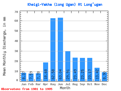
| Statistic | Jan | Feb | Mar | Apr | May | Jun | Jul | Aug | Sep | Oct | Nov | Dec | Annual |
|---|---|---|---|---|---|---|---|---|---|---|---|---|---|
| Mean | 8.37 | 7.65 | 7.77 | 18.68 | 62.58 | 63.04 | 29.91 | 23.49 | 23.25 | 23.16 | 13.42 | 8.90 | 293.20 |
| Standard Deviation | 1.74 | 1.74 | 1.75 | 24.98 | 34.92 | 44.12 | 16.67 | 13.02 | 8.28 | 10.41 | 4.10 | 2.47 | 51.42 |
| Min | 5.75 | 4.76 | 4.75 | 5.33 | 10.11 | 26.17 | 14.55 | 12.88 | 12.84 | 13.00 | 8.04 | 3.94 | 205.33 |
| Max | 10.61 | 10.36 | 10.27 | 80.63 | 106.22 | 157.01 | 60.26 | 55.88 | 38.76 | 45.06 | 21.31 | 12.10 | 393.94 |
| Coefficient of Variation | 0.21 | 0.23 | 0.23 | 1.34 | 0.56 | 0.70 | 0.56 | 0.55 | 0.36 | 0.45 | 0.30 | 0.28 | 0.17 |
 Return to R-Arctic Net Home Page