|
|
|||||||||||||||||
| Point ID: 8668 | Downloads | Plots | Site Data | Code: 11514 |
|
|
|||||||||||||||||
| Download | |
|---|---|
| Site Descriptor Information | Site Time Series Data |
| Link to all available data | |
| View: | Time Series | All |
| Units: | m3/s |
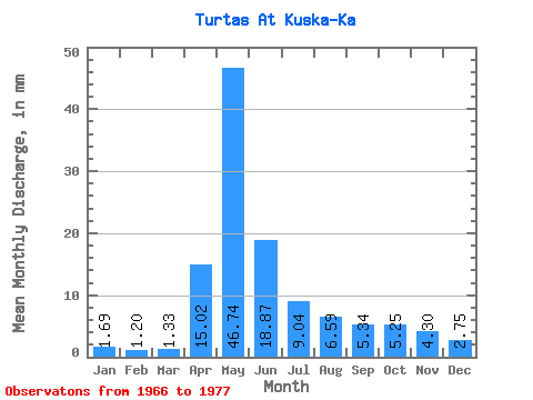
| Statistic | Jan | Feb | Mar | Apr | May | Jun | Jul | Aug | Sep | Oct | Nov | Dec | Annual |
|---|---|---|---|---|---|---|---|---|---|---|---|---|---|
| Mean | 1.69 | 1.21 | 1.33 | 15.02 | 46.73 | 18.88 | 9.04 | 6.58 | 5.34 | 5.25 | 4.30 | 2.75 | 120.50 |
| Standard Deviation | 0.66 | 0.40 | 0.28 | 9.19 | 23.58 | 10.99 | 5.91 | 4.76 | 2.94 | 2.91 | 2.46 | 1.53 | 47.63 |
| Min | 0.81 | 0.59 | 0.68 | 2.66 | 13.34 | 4.68 | 2.83 | 2.10 | 1.45 | 2.06 | 1.37 | 0.86 | 44.08 |
| Max | 3.04 | 1.95 | 1.74 | 31.28 | 89.90 | 41.80 | 24.93 | 15.73 | 10.75 | 11.08 | 9.88 | 5.51 | 208.40 |
| Coefficient of Variation | 0.39 | 0.33 | 0.21 | 0.61 | 0.51 | 0.58 | 0.65 | 0.72 | 0.55 | 0.56 | 0.57 | 0.56 | 0.40 |
 Return to R-Arctic Net Home Page