|
|
|||||||||||||||||
| Point ID: 8659 | Downloads | Plots | Site Data | Code: 11485 |
|
|
|||||||||||||||||
| Download | |
|---|---|
| Site Descriptor Information | Site Time Series Data |
| Link to all available data | |
| View: | Time Series | All |
| Units: | m3/s |
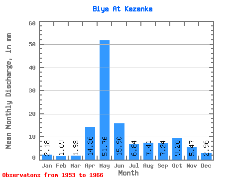
| Statistic | Jan | Feb | Mar | Apr | May | Jun | Jul | Aug | Sep | Oct | Nov | Dec | Annual |
|---|---|---|---|---|---|---|---|---|---|---|---|---|---|
| Mean | 2.18 | 1.70 | 1.93 | 14.36 | 51.75 | 15.90 | 6.84 | 7.41 | 7.24 | 9.25 | 5.47 | 2.96 | 126.05 |
| Standard Deviation | 0.73 | 0.46 | 0.52 | 10.46 | 27.53 | 5.00 | 2.54 | 5.00 | 4.63 | 5.15 | 2.33 | 1.02 | 36.13 |
| Min | 0.71 | 0.53 | 0.96 | 3.52 | 14.40 | 10.06 | 3.13 | 1.64 | 1.66 | 3.50 | 2.17 | 1.24 | 77.18 |
| Max | 3.90 | 2.53 | 3.11 | 37.68 | 103.63 | 26.36 | 12.04 | 17.22 | 16.12 | 16.99 | 8.84 | 5.20 | 212.08 |
| Coefficient of Variation | 0.34 | 0.27 | 0.27 | 0.73 | 0.53 | 0.32 | 0.37 | 0.68 | 0.64 | 0.56 | 0.42 | 0.35 | 0.29 |
 Return to R-Arctic Net Home Page