|
|
|||||||||||||||||
| Point ID: 8657 | Downloads | Plots | Site Data | Code: 11473 |
|
|
|||||||||||||||||
| Download | |
|---|---|
| Site Descriptor Information | Site Time Series Data |
| Link to all available data | |
| View: | Time Series | All |
| Units: | m3/s |
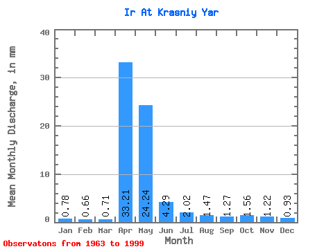
| Statistic | Jan | Feb | Mar | Apr | May | Jun | Jul | Aug | Sep | Oct | Nov | Dec | Annual |
|---|---|---|---|---|---|---|---|---|---|---|---|---|---|
| Mean | 0.78 | 0.67 | 0.71 | 33.21 | 24.24 | 4.29 | 2.02 | 1.47 | 1.27 | 1.56 | 1.22 | 0.93 | 73.16 |
| Standard Deviation | 0.29 | 0.27 | 0.29 | 24.26 | 25.64 | 3.62 | 1.81 | 1.24 | 0.66 | 0.92 | 0.61 | 0.36 | 42.48 |
| Min | 0.14 | 0.06 | 0.00 | 4.27 | 1.67 | 0.83 | 0.69 | 0.53 | 0.55 | 0.49 | 0.11 | 0.40 | 12.61 |
| Max | 1.31 | 1.12 | 1.23 | 101.15 | 121.25 | 15.33 | 8.70 | 7.39 | 3.28 | 4.57 | 2.53 | 1.88 | 151.79 |
| Coefficient of Variation | 0.37 | 0.40 | 0.41 | 0.73 | 1.06 | 0.84 | 0.90 | 0.84 | 0.52 | 0.59 | 0.50 | 0.38 | 0.58 |
 Return to R-Arctic Net Home Page