|
|
|||||||||||||||||
| Point ID: 8656 | Downloads | Plots | Site Data | Code: 11472 |
|
|
|||||||||||||||||
| Download | |
|---|---|
| Site Descriptor Information | Site Time Series Data |
| Link to all available data | |
| View: | Time Series | All |
| Units: | m3/s |
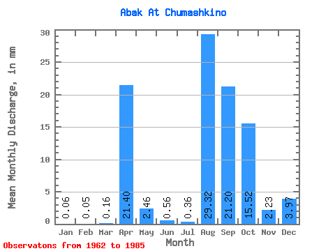
| Statistic | Jan | Feb | Mar | Apr | May | Jun | Jul | Aug | Sep | Oct | Nov | Dec | Annual |
|---|---|---|---|---|---|---|---|---|---|---|---|---|---|
| Mean | 0.06 | 0.04 | 0.15 | 21.40 | 2.46 | 0.56 | 0.37 | 29.31 | 21.20 | 15.52 | 2.22 | 3.97 | 26.34 |
| Standard Deviation | 0.05 | 0.05 | 0.17 | 14.31 | 3.63 | 0.66 | 0.50 | 142.82 | 102.96 | 74.27 | 9.83 | 18.93 | 16.44 |
| Min | 0.00 | 0.00 | 0.00 | 3.32 | 0.31 | 0.12 | 0.00 | 0.00 | 0.01 | 0.06 | 0.04 | 0.00 | 5.16 |
| Max | 0.18 | 0.17 | 0.71 | 57.78 | 16.93 | 3.18 | 1.79 | 699.85 | 504.58 | 364.21 | 48.38 | 92.84 | 71.24 |
| Coefficient of Variation | 0.87 | 1.19 | 1.11 | 0.67 | 1.48 | 1.18 | 1.37 | 4.87 | 4.86 | 4.79 | 4.42 | 4.77 | 0.62 |
 Return to R-Arctic Net Home Page