|
|
|||||||||||||||||
| Point ID: 865 | Downloads | Plots | Site Data | Code: 07ED003 |
|
|
|||||||||||||||||
| Download | |
|---|---|
| Site Descriptor Information | Site Time Series Data |
| Link to all available data | |
| View: | Time Series | All |
| Units: | m3/s |
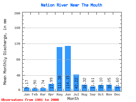
| Statistic | Jan | Feb | Mar | Apr | May | Jun | Jul | Aug | Sep | Oct | Nov | Dec | Annual |
|---|---|---|---|---|---|---|---|---|---|---|---|---|---|
| Mean | 9.17 | 6.96 | 7.74 | 17.99 | 111.36 | 114.15 | 42.21 | 16.32 | 11.61 | 15.10 | 16.05 | 11.60 | 379.31 |
| Standard Deviation | 2.16 | 1.28 | 2.16 | 10.67 | 30.74 | 42.55 | 14.96 | 6.41 | 4.92 | 6.43 | 6.76 | 2.88 | 78.23 |
| Min | 5.66 | 4.79 | 5.62 | 6.29 | 55.39 | 55.54 | 20.16 | 9.17 | 5.32 | 7.01 | 7.52 | 5.54 | 260.18 |
| Max | 15.54 | 9.51 | 14.07 | 52.07 | 183.31 | 192.86 | 78.51 | 29.65 | 23.45 | 26.42 | 33.90 | 16.34 | 561.50 |
| Coefficient of Variation | 0.24 | 0.18 | 0.28 | 0.59 | 0.28 | 0.37 | 0.35 | 0.39 | 0.42 | 0.43 | 0.42 | 0.25 | 0.21 |
 Return to R-Arctic Net Home Page