|
|
|||||||||||||||||
| Point ID: 8623 | Downloads | Plots | Site Data | Code: 11249 |
|
|
|||||||||||||||||
| Download | |
|---|---|
| Site Descriptor Information | Site Time Series Data |
| Link to all available data | |
| View: | Time Series | All |
| Units: | m3/s |
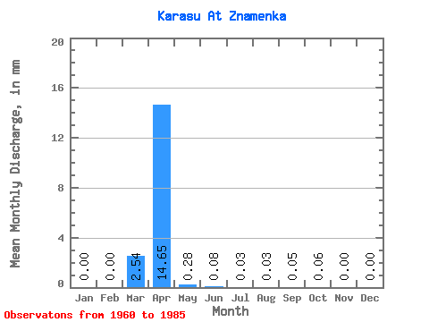
| Statistic | Jan | Feb | Mar | Apr | May | Jun | Jul | Aug | Sep | Oct | Nov | Dec | Annual |
|---|---|---|---|---|---|---|---|---|---|---|---|---|---|
| Mean | 0.00 | 0.00 | 2.53 | 14.64 | 0.29 | 0.07 | 0.03 | 0.02 | 0.05 | 0.06 | 0.01 | 0.00 | 18.81 |
| Standard Deviation | 0.00 | 0.00 | 3.65 | 18.04 | 0.32 | 0.14 | 0.09 | 0.06 | 0.20 | 0.25 | 0.05 | 0.01 | 19.18 |
| Min | 0.00 | 0.00 | 0.00 | 0.30 | 0.00 | 0.00 | 0.00 | 0.00 | 0.00 | 0.00 | 0.00 | 0.00 | 1.63 |
| Max | 0.00 | 0.00 | 10.71 | 51.57 | 1.35 | 0.49 | 0.42 | 0.28 | 0.98 | 1.24 | 0.22 | 0.03 | 59.19 |
| Coefficient of Variation | 1.44 | 1.23 | 1.10 | 1.87 | 2.72 | 3.08 | 3.82 | 3.92 | 3.51 | 5.00 | 1.02 |
 Return to R-Arctic Net Home Page