|
|
|||||||||||||||||
| Point ID: 8620 | Downloads | Plots | Site Data | Code: 11246 |
|
|
|||||||||||||||||
| Download | |
|---|---|
| Site Descriptor Information | Site Time Series Data |
| Link to all available data | |
| View: | Time Series | All |
| Units: | m3/s |
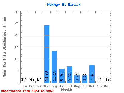
| Statistic | Jan | Feb | Mar | Apr | May | Jun | Jul | Aug | Sep | Oct | Nov | Dec | Annual |
|---|---|---|---|---|---|---|---|---|---|---|---|---|---|
| Mean | 24.02 | 13.28 | 5.70 | 6.93 | 3.25 | 3.22 | 7.42 | ||||||
| Standard Deviation | 8.11 | 10.61 | 3.71 | 3.03 | 2.19 | 3.32 | |||||||
| Min | 18.02 | 0.48 | 1.62 | 4.10 | 1.02 | 0.87 | 7.42 | ||||||
| Max | 33.25 | 26.94 | 11.14 | 9.85 | 6.21 | 5.57 | 7.42 | ||||||
| Coefficient of Variation | 0.34 | 0.80 | 0.65 | 0.44 | 0.67 | 1.03 |
 Return to R-Arctic Net Home Page