|
|
|||||||||||||||||
| Point ID: 861 | Downloads | Plots | Site Data | Code: 07EC002 |
|
|
|||||||||||||||||
| Download | |
|---|---|
| Site Descriptor Information | Site Time Series Data |
| Link to all available data | |
| View: | Time Series | All |
| Units: | m3/s |
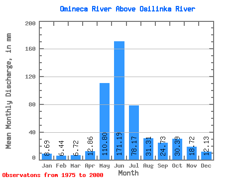
| Statistic | Jan | Feb | Mar | Apr | May | Jun | Jul | Aug | Sep | Oct | Nov | Dec | Annual |
|---|---|---|---|---|---|---|---|---|---|---|---|---|---|
| Mean | 8.69 | 6.49 | 6.72 | 12.86 | 110.79 | 171.19 | 78.16 | 31.30 | 24.73 | 30.38 | 18.72 | 12.12 | 511.46 |
| Standard Deviation | 1.77 | 1.06 | 1.29 | 6.96 | 38.98 | 50.04 | 33.72 | 10.99 | 6.66 | 10.66 | 6.62 | 3.91 | 83.32 |
| Min | 5.71 | 4.67 | 5.17 | 5.90 | 50.73 | 89.70 | 30.15 | 16.34 | 13.55 | 11.17 | 7.84 | 6.54 | 379.27 |
| Max | 13.71 | 8.93 | 10.97 | 40.89 | 173.66 | 244.56 | 176.09 | 65.36 | 37.35 | 48.78 | 35.50 | 23.66 | 690.27 |
| Coefficient of Variation | 0.20 | 0.16 | 0.19 | 0.54 | 0.35 | 0.29 | 0.43 | 0.35 | 0.27 | 0.35 | 0.35 | 0.32 | 0.16 |
 Return to R-Arctic Net Home Page