|
|
|||||||||||||||||
| Point ID: 860 | Downloads | Plots | Site Data | Code: 07EC001 |
|
|
|||||||||||||||||
| Download | |
|---|---|
| Site Descriptor Information | Site Time Series Data |
| Link to all available data | |
| View: | Time Series | All |
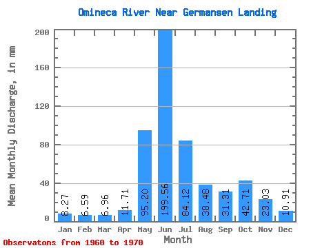
| Units: | m3/s |
| Statistic | Jan | Feb | Mar | Apr | May | Jun | Jul | Aug | Sep | Oct | Nov | Dec | Annual |
|---|---|---|---|---|---|---|---|---|---|---|---|---|---|
| Mean | 8.27 | 6.65 | 6.96 | 11.71 | 95.18 | 199.56 | 84.11 | 38.48 | 31.31 | 42.71 | 23.03 | 10.91 | 560.16 |
| Standard Deviation | 1.49 | 1.23 | 1.28 | 2.95 | 32.45 | 47.73 | 25.79 | 17.19 | 11.45 | 8.36 | 8.96 | 2.57 | 67.77 |
| Min | 6.54 | 5.33 | 5.13 | 7.25 | 54.83 | 148.48 | 40.59 | 18.87 | 16.84 | 32.31 | 15.92 | 7.91 | 469.57 |
| Max | 10.96 | 8.98 | 9.28 | 16.12 | 147.61 | 308.18 | 118.61 | 78.55 | 56.64 | 60.10 | 45.31 | 15.50 | 699.33 |
| Coefficient of Variation | 0.18 | 0.18 | 0.18 | 0.25 | 0.34 | 0.24 | 0.31 | 0.45 | 0.37 | 0.20 | 0.39 | 0.24 | 0.12 |
 Return to R-Arctic Net Home Page