|
|
|||||||||||||||||
| Point ID: 8597 | Downloads | Plots | Site Data | Code: 11191 |
|
|
|||||||||||||||||
| Download | |
|---|---|
| Site Descriptor Information | Site Time Series Data |
| Link to all available data | |
| View: | Time Series | All |
| Units: | m3/s |
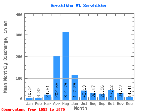
| Statistic | Jan | Feb | Mar | Apr | May | Jun | Jul | Aug | Sep | Oct | Nov | Dec | Annual |
|---|---|---|---|---|---|---|---|---|---|---|---|---|---|
| Mean | 10.23 | 8.39 | 24.51 | 202.64 | 314.75 | 117.29 | 43.12 | 32.06 | 28.96 | 47.11 | 34.18 | 14.40 | 882.55 |
| Standard Deviation | 2.64 | 2.61 | 20.99 | 56.64 | 135.63 | 100.02 | 32.08 | 24.14 | 25.30 | 30.92 | 16.04 | 5.99 | 240.58 |
| Min | 6.04 | 4.43 | 5.21 | 121.57 | 123.23 | 18.58 | 9.60 | 6.87 | 8.72 | 16.00 | 10.90 | 6.16 | 588.96 |
| Max | 15.76 | 14.90 | 88.28 | 302.78 | 596.03 | 350.95 | 117.67 | 87.57 | 112.74 | 118.50 | 65.14 | 27.02 | 1351.32 |
| Coefficient of Variation | 0.26 | 0.31 | 0.86 | 0.28 | 0.43 | 0.85 | 0.74 | 0.75 | 0.87 | 0.66 | 0.47 | 0.41 | 0.27 |
 Return to R-Arctic Net Home Page