|
|
|||||||||||||||||
| Point ID: 859 | Downloads | Plots | Site Data | Code: 07EB002 |
|
|
|||||||||||||||||
| Download | |
|---|---|
| Site Descriptor Information | Site Time Series Data |
| Link to all available data | |
| View: | Time Series | All |
| Units: | m3/s |
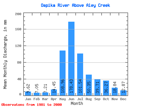
| Statistic | Jan | Feb | Mar | Apr | May | Jun | Jul | Aug | Sep | Oct | Nov | Dec | Annual |
|---|---|---|---|---|---|---|---|---|---|---|---|---|---|
| Mean | 9.62 | 7.11 | 7.21 | 14.45 | 108.94 | 178.43 | 101.52 | 50.34 | 39.71 | 36.26 | 18.84 | 12.87 | 583.69 |
| Standard Deviation | 1.85 | 1.10 | 1.22 | 5.71 | 43.38 | 45.06 | 32.62 | 13.98 | 14.21 | 14.66 | 5.84 | 3.29 | 71.91 |
| Min | 6.21 | 4.02 | 3.63 | 6.78 | 45.24 | 90.49 | 56.34 | 28.23 | 20.67 | 11.87 | 7.71 | 6.80 | 467.01 |
| Max | 13.15 | 8.84 | 9.77 | 30.24 | 191.80 | 245.19 | 191.80 | 74.19 | 67.84 | 74.07 | 33.86 | 18.94 | 705.92 |
| Coefficient of Variation | 0.19 | 0.15 | 0.17 | 0.40 | 0.40 | 0.25 | 0.32 | 0.28 | 0.36 | 0.40 | 0.31 | 0.26 | 0.12 |
 Return to R-Arctic Net Home Page