|
|
|||||||||||||||||
| Point ID: 8581 | Downloads | Plots | Site Data | Code: 11160 |
|
|
|||||||||||||||||
| Download | |
|---|---|
| Site Descriptor Information | Site Time Series Data |
| Link to all available data | |
| View: | Time Series | All |
| Units: | m3/s |
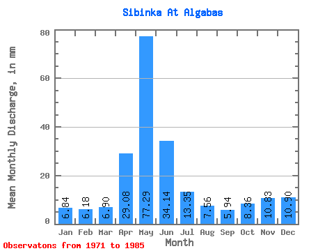
| Statistic | Jan | Feb | Mar | Apr | May | Jun | Jul | Aug | Sep | Oct | Nov | Dec | Annual |
|---|---|---|---|---|---|---|---|---|---|---|---|---|---|
| Mean | 6.84 | 6.23 | 6.90 | 29.09 | 77.29 | 34.14 | 13.35 | 7.56 | 5.93 | 8.36 | 10.82 | 10.91 | 267.66 |
| Standard Deviation | 4.08 | 3.37 | 2.91 | 14.25 | 35.36 | 23.42 | 8.42 | 4.16 | 2.62 | 5.27 | 5.54 | 8.34 | 112.92 |
| Min | 2.85 | 3.12 | 3.99 | 10.48 | 24.50 | 3.12 | 1.90 | 1.69 | 2.02 | 2.85 | 4.60 | 4.94 | 140.08 |
| Max | 13.68 | 11.94 | 12.35 | 51.66 | 135.23 | 71.33 | 30.77 | 17.66 | 11.95 | 20.32 | 19.85 | 27.73 | 354.77 |
| Coefficient of Variation | 0.60 | 0.54 | 0.42 | 0.49 | 0.46 | 0.69 | 0.63 | 0.55 | 0.44 | 0.63 | 0.51 | 0.76 | 0.42 |
 Return to R-Arctic Net Home Page