|
|
|||||||||||||||||
| Point ID: 8578 | Downloads | Plots | Site Data | Code: 11152 |
|
|
|||||||||||||||||
| Download | |
|---|---|
| Site Descriptor Information | Site Time Series Data |
| Link to all available data | |
| View: | Time Series | All |
| Units: | m3/s |
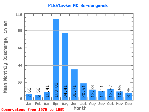
| Statistic | Jan | Feb | Mar | Apr | May | Jun | Jul | Aug | Sep | Oct | Nov | Dec | Annual |
|---|---|---|---|---|---|---|---|---|---|---|---|---|---|
| Mean | 7.64 | 6.60 | 10.43 | 103.02 | 84.38 | 38.72 | 20.90 | 13.34 | 11.09 | 13.56 | 10.64 | 8.95 | 329.34 |
| Standard Deviation | 1.45 | 0.93 | 4.63 | 33.70 | 48.21 | 20.26 | 9.18 | 3.86 | 2.38 | 7.03 | 3.05 | 1.71 | 95.69 |
| Min | 5.52 | 5.39 | 6.31 | 48.48 | 15.07 | 11.45 | 9.07 | 6.31 | 6.87 | 8.68 | 6.11 | 6.31 | 191.73 |
| Max | 10.65 | 8.62 | 25.64 | 171.02 | 168.02 | 79.40 | 40.62 | 22.09 | 15.27 | 38.26 | 17.18 | 12.23 | 481.84 |
| Coefficient of Variation | 0.19 | 0.14 | 0.44 | 0.33 | 0.57 | 0.52 | 0.44 | 0.29 | 0.21 | 0.52 | 0.29 | 0.19 | 0.29 |
 Return to R-Arctic Net Home Page