|
|
|||||||||||||||||
| Point ID: 857 | Downloads | Plots | Site Data | Code: 07EA007 |
|
|
|||||||||||||||||
| Download | |
|---|---|
| Site Descriptor Information | Site Time Series Data |
| Link to all available data | |
| View: | Time Series | All |
| Units: | m3/s |
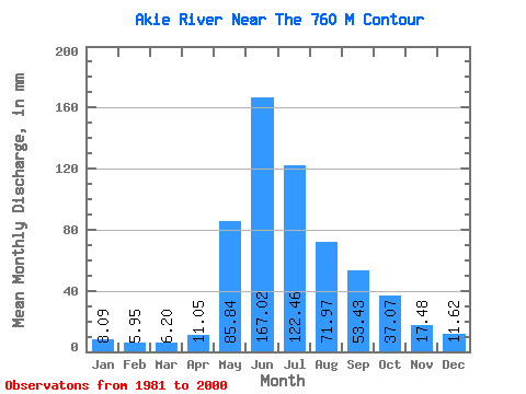
| Statistic | Jan | Feb | Mar | Apr | May | Jun | Jul | Aug | Sep | Oct | Nov | Dec | Annual |
|---|---|---|---|---|---|---|---|---|---|---|---|---|---|
| Mean | 8.09 | 6.00 | 6.20 | 11.05 | 85.83 | 167.02 | 122.44 | 71.96 | 53.43 | 37.07 | 17.48 | 11.62 | 596.15 |
| Standard Deviation | 1.64 | 0.92 | 0.89 | 4.61 | 40.09 | 40.65 | 32.39 | 21.06 | 17.62 | 13.40 | 4.87 | 3.22 | 75.76 |
| Min | 4.90 | 4.31 | 4.54 | 5.98 | 25.84 | 101.85 | 70.10 | 47.10 | 29.43 | 12.43 | 7.36 | 6.11 | 435.31 |
| Max | 11.39 | 7.82 | 8.21 | 26.53 | 163.83 | 239.38 | 189.03 | 130.12 | 90.11 | 58.13 | 28.36 | 17.49 | 755.77 |
| Coefficient of Variation | 0.20 | 0.15 | 0.14 | 0.42 | 0.47 | 0.24 | 0.27 | 0.29 | 0.33 | 0.36 | 0.28 | 0.28 | 0.13 |
 Return to R-Arctic Net Home Page