|
|
|||||||||||||||||
| Point ID: 8569 | Downloads | Plots | Site Data | Code: 11114 |
|
|
|||||||||||||||||
| Download | |
|---|---|
| Site Descriptor Information | Site Time Series Data |
| Link to all available data | |
| View: | Time Series | All |
| Units: | m3/s |
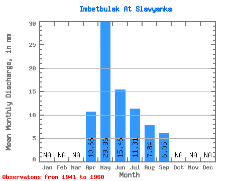
| Statistic | Jan | Feb | Mar | Apr | May | Jun | Jul | Aug | Sep | Oct | Nov | Dec | Annual |
|---|---|---|---|---|---|---|---|---|---|---|---|---|---|
| Mean | 10.62 | 29.82 | 15.42 | 11.27 | 7.80 | 6.03 | |||||||
| Standard Deviation | 31.04 | 9.33 | 5.25 | 2.83 | 0.66 | ||||||||
| Min | 10.62 | 7.99 | 4.86 | 3.08 | 4.32 | 5.24 | |||||||
| Max | 10.62 | 75.44 | 32.70 | 18.94 | 12.95 | 6.78 | |||||||
| Coefficient of Variation | 1.04 | 0.60 | 0.47 | 0.36 | 0.11 |
 Return to R-Arctic Net Home Page