|
|
|||||||||||||||||
| Point ID: 8529 | Downloads | Plots | Site Data | Code: 10612 |
|
|
|||||||||||||||||
| Download | |
|---|---|
| Site Descriptor Information | Site Time Series Data |
| Link to all available data | |
| View: | Time Series | All |
| Units: | m3/s |
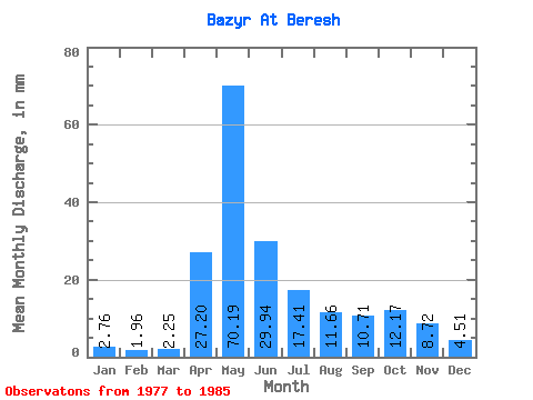
| Statistic | Jan | Feb | Mar | Apr | May | Jun | Jul | Aug | Sep | Oct | Nov | Dec | Annual |
|---|---|---|---|---|---|---|---|---|---|---|---|---|---|
| Mean | 2.76 | 1.98 | 2.25 | 27.20 | 70.18 | 29.95 | 17.41 | 11.66 | 10.71 | 12.17 | 8.72 | 4.52 | 198.60 |
| Standard Deviation | 0.59 | 0.89 | 0.81 | 11.39 | 23.47 | 13.60 | 5.19 | 3.19 | 4.32 | 2.48 | 3.27 | 1.13 | 41.65 |
| Min | 1.88 | 0.90 | 1.16 | 8.84 | 34.48 | 12.83 | 7.17 | 6.90 | 7.20 | 8.15 | 5.46 | 3.40 | 128.86 |
| Max | 3.49 | 3.35 | 3.67 | 39.70 | 100.31 | 58.95 | 23.64 | 18.36 | 20.72 | 15.49 | 15.78 | 6.72 | 279.71 |
| Coefficient of Variation | 0.21 | 0.45 | 0.36 | 0.42 | 0.33 | 0.45 | 0.30 | 0.27 | 0.40 | 0.20 | 0.38 | 0.25 | 0.21 |
 Return to R-Arctic Net Home Page