|
|
|||||||||||||||||
| Point ID: 8521 | Downloads | Plots | Site Data | Code: 10547 |
|
|
|||||||||||||||||
| Download | |
|---|---|
| Site Descriptor Information | Site Time Series Data |
| Link to all available data | |
| View: | Time Series | All |
| Units: | m3/s |
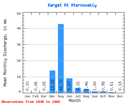
| Statistic | Jan | Feb | Mar | Apr | May | Jun | Jul | Aug | Sep | Oct | Nov | Dec | Annual |
|---|---|---|---|---|---|---|---|---|---|---|---|---|---|
| Mean | 0.10 | 0.06 | 0.05 | 13.91 | 42.70 | 9.07 | 3.15 | 2.46 | 1.00 | 0.98 | 0.52 | 0.14 | 74.98 |
| Standard Deviation | 0.14 | 0.06 | 0.06 | 14.70 | 42.58 | 10.26 | 5.82 | 4.69 | 1.77 | 1.75 | 0.71 | 0.18 | 71.84 |
| Min | 0.00 | 0.00 | 0.00 | 0.34 | 5.66 | 0.24 | 0.04 | 0.01 | 0.00 | 0.00 | 0.00 | 0.00 | 11.66 |
| Max | 0.56 | 0.20 | 0.20 | 52.67 | 176.39 | 32.17 | 25.36 | 15.31 | 7.32 | 6.51 | 2.72 | 0.62 | 280.02 |
| Coefficient of Variation | 1.45 | 1.10 | 1.13 | 1.06 | 1.00 | 1.13 | 1.85 | 1.91 | 1.77 | 1.79 | 1.38 | 1.24 | 0.96 |
 Return to R-Arctic Net Home Page