|
|
|||||||||||||||||
| Point ID: 8501 | Downloads | Plots | Site Data | Code: 10443 |
|
|
|||||||||||||||||
| Download | |
|---|---|
| Site Descriptor Information | Site Time Series Data |
| Link to all available data | |
| View: | Time Series | All |
| Units: | m3/s |
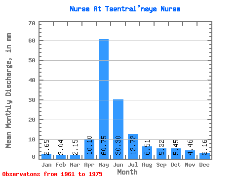
| Statistic | Jan | Feb | Mar | Apr | May | Jun | Jul | Aug | Sep | Oct | Nov | Dec | Annual |
|---|---|---|---|---|---|---|---|---|---|---|---|---|---|
| Mean | 2.66 | 2.06 | 2.15 | 10.10 | 60.74 | 30.30 | 12.72 | 6.51 | 5.32 | 5.45 | 4.46 | 3.16 | 145.22 |
| Standard Deviation | 0.92 | 0.58 | 0.55 | 10.08 | 30.61 | 22.96 | 19.19 | 4.07 | 2.10 | 2.22 | 2.14 | 1.25 | 69.49 |
| Min | 1.68 | 1.11 | 1.44 | 2.28 | 10.59 | 6.35 | 2.35 | 2.66 | 2.71 | 2.66 | 2.19 | 1.85 | 51.57 |
| Max | 5.15 | 3.46 | 3.38 | 37.55 | 116.73 | 87.73 | 78.80 | 17.85 | 8.76 | 10.28 | 9.70 | 6.76 | 273.45 |
| Coefficient of Variation | 0.34 | 0.28 | 0.25 | 1.00 | 0.50 | 0.76 | 1.51 | 0.63 | 0.40 | 0.41 | 0.48 | 0.40 | 0.48 |
 Return to R-Arctic Net Home Page