|
|
|||||||||||||||||
| Point ID: 8499 | Downloads | Plots | Site Data | Code: 10417 |
|
|
|||||||||||||||||
| Download | |
|---|---|
| Site Descriptor Information | Site Time Series Data |
| Link to all available data | |
| View: | Time Series | All |
| Units: | m3/s |
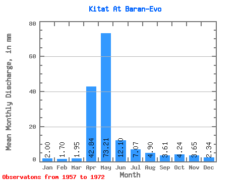
| Statistic | Jan | Feb | Mar | Apr | May | Jun | Jul | Aug | Sep | Oct | Nov | Dec | Annual |
|---|---|---|---|---|---|---|---|---|---|---|---|---|---|
| Mean | 2.00 | 1.72 | 1.95 | 42.84 | 73.20 | 12.10 | 7.07 | 4.90 | 3.60 | 4.24 | 3.65 | 2.34 | 156.53 |
| Standard Deviation | 0.54 | 0.40 | 0.50 | 26.42 | 42.73 | 7.40 | 7.57 | 3.59 | 1.22 | 1.76 | 1.60 | 0.75 | 41.80 |
| Min | 1.43 | 1.27 | 1.29 | 5.42 | 18.06 | 4.70 | 1.57 | 2.14 | 1.94 | 2.28 | 1.91 | 1.61 | 82.28 |
| Max | 3.30 | 2.44 | 3.19 | 98.25 | 142.00 | 30.98 | 33.51 | 16.44 | 5.73 | 7.90 | 7.37 | 4.57 | 213.85 |
| Coefficient of Variation | 0.27 | 0.23 | 0.26 | 0.62 | 0.58 | 0.61 | 1.07 | 0.73 | 0.34 | 0.41 | 0.44 | 0.32 | 0.27 |
 Return to R-Arctic Net Home Page