|
|
|||||||||||||||||
| Point ID: 8492 | Downloads | Plots | Site Data | Code: 10397 |
|
|
|||||||||||||||||
| Download | |
|---|---|
| Site Descriptor Information | Site Time Series Data |
| Link to all available data | |
| View: | Time Series | All |
| Units: | m3/s |
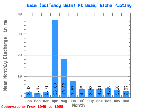
| Statistic | Jan | Feb | Mar | Apr | May | Jun | Jul | Aug | Sep | Oct | Nov | Dec | Annual |
|---|---|---|---|---|---|---|---|---|---|---|---|---|---|
| Mean | 2.44 | 2.00 | 2.69 | 36.80 | 18.20 | 7.67 | 4.06 | 3.92 | 4.01 | 4.30 | 3.68 | 2.87 | 92.86 |
| Standard Deviation | 1.09 | 1.02 | 1.77 | 15.95 | 15.82 | 4.98 | 1.08 | 1.27 | 1.38 | 1.38 | 1.62 | 1.12 | 29.65 |
| Min | 0.81 | 0.88 | 0.87 | 15.37 | 6.23 | 3.31 | 2.27 | 1.84 | 2.11 | 2.18 | 1.33 | 0.81 | 60.58 |
| Max | 4.36 | 3.97 | 7.18 | 62.99 | 66.95 | 18.08 | 6.23 | 5.92 | 6.33 | 6.54 | 6.35 | 4.38 | 150.47 |
| Coefficient of Variation | 0.45 | 0.51 | 0.66 | 0.43 | 0.87 | 0.65 | 0.27 | 0.33 | 0.34 | 0.32 | 0.44 | 0.39 | 0.32 |
 Return to R-Arctic Net Home Page