|
|
|||||||||||||||||
| Point ID: 8490 | Downloads | Plots | Site Data | Code: 10391 |
|
|
|||||||||||||||||
| Download | |
|---|---|
| Site Descriptor Information | Site Time Series Data |
| Link to all available data | |
| View: | Time Series | All |
| Units: | m3/s |
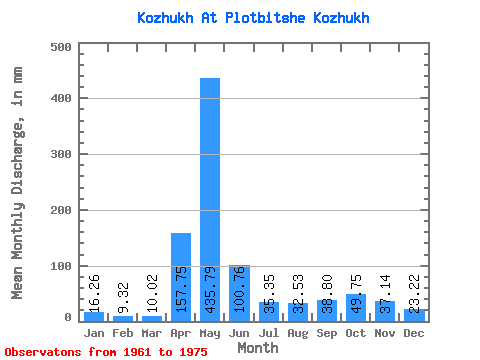
| Statistic | Jan | Feb | Mar | Apr | May | Jun | Jul | Aug | Sep | Oct | Nov | Dec | Annual |
|---|---|---|---|---|---|---|---|---|---|---|---|---|---|
| Mean | 16.26 | 9.40 | 10.02 | 157.75 | 435.72 | 100.76 | 35.34 | 32.52 | 38.80 | 49.75 | 37.14 | 23.21 | 946.20 |
| Standard Deviation | 22.72 | 11.64 | 9.91 | 116.31 | 133.60 | 60.78 | 26.34 | 21.15 | 29.64 | 21.74 | 24.10 | 23.32 | 177.75 |
| Min | 1.29 | 1.16 | 1.59 | 25.54 | 188.06 | 20.16 | 7.64 | 12.22 | 7.45 | 16.15 | 8.10 | 4.72 | 661.46 |
| Max | 73.20 | 41.93 | 36.10 | 382.08 | 601.06 | 215.04 | 79.55 | 79.55 | 110.98 | 78.95 | 97.15 | 74.98 | 1233.51 |
| Coefficient of Variation | 1.40 | 1.24 | 0.99 | 0.74 | 0.31 | 0.60 | 0.74 | 0.65 | 0.76 | 0.44 | 0.65 | 1.00 | 0.19 |
 Return to R-Arctic Net Home Page