|
|
|||||||||||||||||
| Point ID: 8488 | Downloads | Plots | Site Data | Code: 10371 |
|
|
|||||||||||||||||
| Download | |
|---|---|
| Site Descriptor Information | Site Time Series Data |
| Link to all available data | |
| View: | Time Series | All |
| Units: | m3/s |
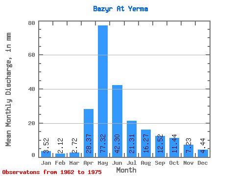
| Statistic | Jan | Feb | Mar | Apr | May | Jun | Jul | Aug | Sep | Oct | Nov | Dec | Annual |
|---|---|---|---|---|---|---|---|---|---|---|---|---|---|
| Mean | 3.52 | 2.14 | 2.72 | 28.37 | 77.31 | 42.29 | 21.30 | 16.27 | 12.51 | 11.43 | 7.24 | 4.44 | 228.49 |
| Standard Deviation | 1.65 | 1.30 | 1.40 | 17.84 | 34.21 | 24.79 | 11.97 | 10.60 | 6.37 | 5.08 | 3.91 | 2.36 | 74.06 |
| Min | 1.72 | 0.49 | 0.81 | 6.58 | 37.20 | 12.92 | 7.32 | 4.99 | 6.58 | 5.17 | 4.17 | 2.24 | 139.19 |
| Max | 7.58 | 5.41 | 5.42 | 69.34 | 139.50 | 94.18 | 52.96 | 39.09 | 29.17 | 23.68 | 18.84 | 10.85 | 359.91 |
| Coefficient of Variation | 0.47 | 0.61 | 0.52 | 0.63 | 0.44 | 0.59 | 0.56 | 0.65 | 0.51 | 0.45 | 0.54 | 0.53 | 0.32 |
 Return to R-Arctic Net Home Page