|
|
|||||||||||||||||
| Point ID: 8487 | Downloads | Plots | Site Data | Code: 10370 |
|
|
|||||||||||||||||
| Download | |
|---|---|
| Site Descriptor Information | Site Time Series Data |
| Link to all available data | |
| View: | Time Series | All |
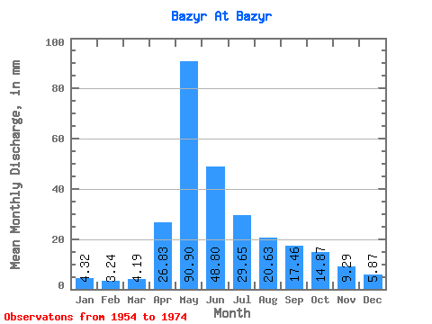
| Units: | m3/s |
| Statistic | Jan | Feb | Mar | Apr | May | Jun | Jul | Aug | Sep | Oct | Nov | Dec | Annual |
|---|---|---|---|---|---|---|---|---|---|---|---|---|---|
| Mean | 4.33 | 3.27 | 4.18 | 26.83 | 90.89 | 48.80 | 29.65 | 20.62 | 17.46 | 14.87 | 9.28 | 5.88 | 277.39 |
| Standard Deviation | 1.54 | 1.44 | 1.32 | 11.88 | 33.29 | 22.42 | 16.10 | 12.18 | 9.02 | 5.95 | 4.24 | 2.12 | 57.68 |
| Min | 2.04 | 0.46 | 0.99 | 8.03 | 42.28 | 15.53 | 9.65 | 7.21 | 7.37 | 6.80 | 5.00 | 2.99 | 179.96 |
| Max | 7.48 | 5.82 | 6.80 | 49.47 | 156.33 | 99.34 | 71.64 | 51.25 | 40.92 | 25.69 | 19.47 | 10.47 | 377.68 |
| Coefficient of Variation | 0.35 | 0.44 | 0.32 | 0.44 | 0.37 | 0.46 | 0.54 | 0.59 | 0.52 | 0.40 | 0.46 | 0.36 | 0.21 |
 Return to R-Arctic Net Home Page