|
|
|||||||||||||||||
| Point ID: 8485 | Downloads | Plots | Site Data | Code: 10360 |
|
|
|||||||||||||||||
| Download | |
|---|---|
| Site Descriptor Information | Site Time Series Data |
| Link to all available data | |
| View: | Time Series | All |
| Units: | m3/s |
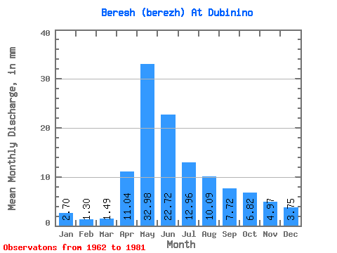
| Statistic | Jan | Feb | Mar | Apr | May | Jun | Jul | Aug | Sep | Oct | Nov | Dec | Annual |
|---|---|---|---|---|---|---|---|---|---|---|---|---|---|
| Mean | 2.70 | 1.31 | 1.49 | 11.04 | 32.98 | 22.72 | 12.96 | 10.09 | 7.71 | 6.82 | 4.97 | 3.75 | 117.96 |
| Standard Deviation | 1.63 | 0.86 | 1.20 | 7.42 | 14.09 | 17.66 | 8.19 | 6.14 | 3.82 | 2.78 | 1.66 | 1.73 | 45.98 |
| Min | 1.20 | 0.30 | 0.22 | 0.16 | 16.88 | 2.96 | 4.02 | 3.92 | 3.27 | 3.45 | 3.22 | 1.40 | 54.85 |
| Max | 6.17 | 3.68 | 5.52 | 27.27 | 62.41 | 75.39 | 41.92 | 25.03 | 18.26 | 15.37 | 10.06 | 7.85 | 237.42 |
| Coefficient of Variation | 0.60 | 0.66 | 0.80 | 0.67 | 0.43 | 0.78 | 0.63 | 0.61 | 0.50 | 0.41 | 0.33 | 0.46 | 0.39 |
 Return to R-Arctic Net Home Page