|
|
|||||||||||||||||
| Point ID: 8483 | Downloads | Plots | Site Data | Code: 10334 |
|
|
|||||||||||||||||
| Download | |
|---|---|
| Site Descriptor Information | Site Time Series Data |
| Link to all available data | |
| View: | Time Series | All |
| Units: | m3/s |
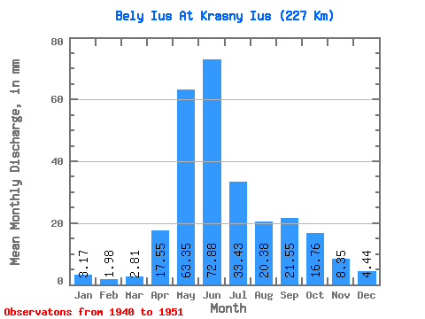
| Statistic | Jan | Feb | Mar | Apr | May | Jun | Jul | Aug | Sep | Oct | Nov | Dec | Annual |
|---|---|---|---|---|---|---|---|---|---|---|---|---|---|
| Mean | 3.17 | 2.00 | 2.81 | 17.55 | 63.34 | 72.88 | 33.42 | 20.38 | 21.55 | 16.75 | 8.35 | 4.44 | 290.92 |
| Standard Deviation | 1.20 | 0.77 | 0.90 | 7.90 | 9.54 | 42.22 | 12.41 | 5.82 | 10.37 | 6.58 | 5.41 | 1.71 | 64.23 |
| Min | 1.38 | 0.81 | 1.50 | 4.64 | 50.74 | 21.74 | 16.71 | 14.77 | 7.93 | 8.58 | 3.01 | 2.87 | 234.19 |
| Max | 5.70 | 3.23 | 4.21 | 28.70 | 80.23 | 149.41 | 64.18 | 33.42 | 47.13 | 30.93 | 17.57 | 8.02 | 393.46 |
| Coefficient of Variation | 0.38 | 0.39 | 0.32 | 0.45 | 0.15 | 0.58 | 0.37 | 0.29 | 0.48 | 0.39 | 0.65 | 0.38 | 0.22 |
 Return to R-Arctic Net Home Page