|
|
|||||||||||||||||
| Point ID: 8475 | Downloads | Plots | Site Data | Code: 10309 |
|
|
|||||||||||||||||
| Download | |
|---|---|
| Site Descriptor Information | Site Time Series Data |
| Link to all available data | |
| View: | Time Series | All |
| Units: | m3/s |
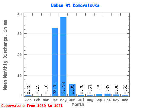
| Statistic | Jan | Feb | Mar | Apr | May | Jun | Jul | Aug | Sep | Oct | Nov | Dec | Annual |
|---|---|---|---|---|---|---|---|---|---|---|---|---|---|
| Mean | 0.46 | 0.19 | 0.10 | 32.74 | 37.93 | 6.05 | 0.76 | 0.57 | 1.19 | 1.39 | 0.97 | 0.53 | 63.80 |
| Standard Deviation | 1.38 | 0.57 | 0.21 | 32.48 | 38.99 | 6.08 | 0.95 | 1.30 | 2.15 | 1.97 | 1.73 | 1.57 | 61.09 |
| Min | 0.00 | 0.00 | 0.00 | 0.73 | 0.23 | 0.00 | 0.00 | 0.00 | 0.00 | 0.00 | 0.00 | 0.00 | 0.96 |
| Max | 4.61 | 1.90 | 0.63 | 112.96 | 123.95 | 17.08 | 2.71 | 4.16 | 5.25 | 4.71 | 5.43 | 5.25 | 195.60 |
| Coefficient of Variation | 3.03 | 3.06 | 2.04 | 0.99 | 1.03 | 1.00 | 1.25 | 2.29 | 1.80 | 1.42 | 1.79 | 2.97 | 0.96 |
 Return to R-Arctic Net Home Page