|
|
|||||||||||||||||
| Point ID: 8447 | Downloads | Plots | Site Data | Code: 10179 |
|
|
|||||||||||||||||
| Download | |
|---|---|
| Site Descriptor Information | Site Time Series Data |
| Link to all available data | |
| View: | Time Series | All |
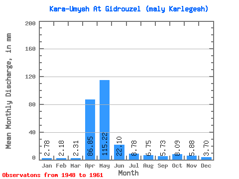
| Units: | m3/s |
| Statistic | Jan | Feb | Mar | Apr | May | Jun | Jul | Aug | Sep | Oct | Nov | Dec | Annual |
|---|---|---|---|---|---|---|---|---|---|---|---|---|---|
| Mean | 2.77 | 2.20 | 2.31 | 86.85 | 115.20 | 22.10 | 8.78 | 6.75 | 5.73 | 8.09 | 5.88 | 3.70 | 267.38 |
| Standard Deviation | 1.23 | 1.28 | 1.22 | 52.28 | 45.33 | 16.92 | 4.13 | 3.66 | 4.46 | 6.81 | 4.05 | 1.61 | 43.01 |
| Min | 1.15 | 0.81 | 0.84 | 5.87 | 42.14 | 5.91 | 1.73 | 2.52 | 0.47 | 1.06 | 1.50 | 1.37 | 197.19 |
| Max | 5.18 | 4.32 | 4.21 | 171.37 | 200.96 | 52.70 | 15.94 | 14.16 | 12.72 | 23.15 | 15.47 | 6.46 | 361.50 |
| Coefficient of Variation | 0.44 | 0.58 | 0.53 | 0.60 | 0.39 | 0.77 | 0.47 | 0.54 | 0.78 | 0.84 | 0.69 | 0.43 | 0.16 |
 Return to R-Arctic Net Home Page