|
|
|||||||||||||||||
| Point ID: 8445 | Downloads | Plots | Site Data | Code: 10166 |
|
|
|||||||||||||||||
| Download | |
|---|---|
| Site Descriptor Information | Site Time Series Data |
| Link to all available data | |
| View: | Time Series | All |
| Units: | m3/s |
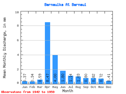
| Statistic | Jan | Feb | Mar | Apr | May | Jun | Jul | Aug | Sep | Oct | Nov | Dec | Annual |
|---|---|---|---|---|---|---|---|---|---|---|---|---|---|
| Mean | 0.37 | 0.34 | 0.59 | 8.47 | 4.00 | 1.80 | 1.14 | 1.03 | 0.80 | 0.82 | 0.72 | 0.41 | 20.55 |
| Standard Deviation | 0.15 | 0.13 | 0.36 | 4.32 | 2.06 | 0.97 | 0.72 | 0.66 | 0.39 | 0.32 | 0.70 | 0.22 | 8.09 |
| Min | 0.03 | 0.14 | 0.23 | 1.82 | 1.75 | 0.58 | 0.28 | 0.37 | 0.26 | 0.44 | 0.08 | 0.10 | 6.92 |
| Max | 0.59 | 0.60 | 1.34 | 15.81 | 8.66 | 4.34 | 3.28 | 2.64 | 1.60 | 1.29 | 3.08 | 0.78 | 37.77 |
| Coefficient of Variation | 0.41 | 0.37 | 0.60 | 0.51 | 0.52 | 0.54 | 0.63 | 0.64 | 0.48 | 0.39 | 0.96 | 0.53 | 0.39 |
 Return to R-Arctic Net Home Page