|
|
|||||||||||||||||
| Point ID: 8441 | Downloads | Plots | Site Data | Code: 10156 |
|
|
|||||||||||||||||
| Download | |
|---|---|
| Site Descriptor Information | Site Time Series Data |
| Link to all available data | |
| View: | Time Series | All |
| Units: | m3/s |
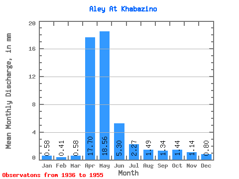
| Statistic | Jan | Feb | Mar | Apr | May | Jun | Jul | Aug | Sep | Oct | Nov | Dec | Annual |
|---|---|---|---|---|---|---|---|---|---|---|---|---|---|
| Mean | 0.58 | 0.41 | 0.58 | 17.70 | 18.56 | 5.30 | 2.27 | 1.48 | 1.34 | 1.44 | 1.14 | 0.80 | 51.55 |
| Standard Deviation | 0.26 | 0.24 | 0.58 | 7.35 | 9.62 | 3.88 | 1.42 | 0.68 | 0.70 | 0.66 | 0.44 | 0.29 | 14.12 |
| Min | 0.14 | 0.04 | 0.05 | 1.42 | 6.96 | 1.37 | 0.66 | 0.56 | 0.53 | 0.64 | 0.48 | 0.29 | 21.89 |
| Max | 1.13 | 0.95 | 2.42 | 27.91 | 40.69 | 18.44 | 6.62 | 3.00 | 3.40 | 3.27 | 1.97 | 1.43 | 83.43 |
| Coefficient of Variation | 0.45 | 0.58 | 1.01 | 0.41 | 0.52 | 0.73 | 0.63 | 0.46 | 0.52 | 0.46 | 0.39 | 0.37 | 0.27 |
 Return to R-Arctic Net Home Page