|
|
|||||||||||||||||
| Point ID: 8433 | Downloads | Plots | Site Data | Code: 10109 |
|
|
|||||||||||||||||
| Download | |
|---|---|
| Site Descriptor Information | Site Time Series Data |
| Link to all available data | |
| View: | Time Series | All |
| Units: | m3/s |
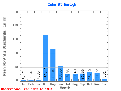
| Statistic | Jan | Feb | Mar | Apr | May | Jun | Jul | Aug | Sep | Oct | Nov | Dec | Annual |
|---|---|---|---|---|---|---|---|---|---|---|---|---|---|
| Mean | 3.46 | 2.56 | 4.85 | 132.42 | 91.92 | 43.55 | 19.36 | 20.49 | 21.56 | 26.40 | 23.72 | 7.31 | 409.70 |
| Standard Deviation | 1.47 | 0.99 | 3.77 | 43.33 | 39.90 | 26.25 | 13.84 | 15.97 | 19.94 | 17.41 | 25.76 | 4.16 | 129.23 |
| Min | 1.49 | 1.39 | 1.69 | 71.93 | 32.30 | 5.49 | 4.10 | 3.45 | 3.50 | 5.29 | 3.22 | 2.26 | 245.65 |
| Max | 5.99 | 4.89 | 13.26 | 199.26 | 159.51 | 82.94 | 49.38 | 48.04 | 52.33 | 65.44 | 88.61 | 15.88 | 581.46 |
| Coefficient of Variation | 0.42 | 0.39 | 0.78 | 0.33 | 0.43 | 0.60 | 0.71 | 0.78 | 0.93 | 0.66 | 1.09 | 0.57 | 0.32 |
 Return to R-Arctic Net Home Page