|
|
|||||||||||||||||
| Point ID: 8427 | Downloads | Plots | Site Data | Code: 10097 |
|
|
|||||||||||||||||
| Download | |
|---|---|
| Site Descriptor Information | Site Time Series Data |
| Link to all available data | |
| View: | Time Series | All |
| Units: | m3/s |
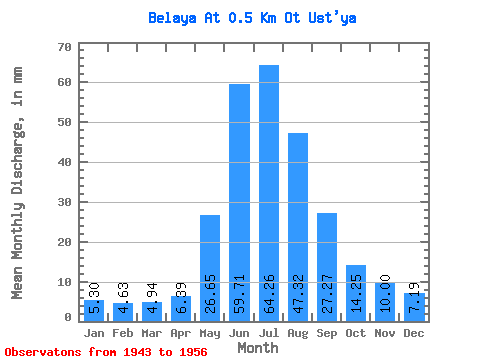
| Statistic | Jan | Feb | Mar | Apr | May | Jun | Jul | Aug | Sep | Oct | Nov | Dec | Annual |
|---|---|---|---|---|---|---|---|---|---|---|---|---|---|
| Mean | 5.29 | 4.67 | 4.93 | 6.38 | 26.66 | 59.73 | 64.25 | 47.33 | 27.25 | 14.23 | 10.00 | 7.19 | 276.74 |
| Standard Deviation | 1.51 | 1.40 | 1.37 | 1.76 | 9.99 | 24.69 | 44.31 | 18.10 | 18.09 | 5.58 | 3.72 | 1.56 | 121.31 |
| Min | 3.73 | 3.36 | 3.55 | 4.78 | 20.67 | 40.01 | 26.96 | 26.96 | 13.92 | 10.78 | 6.09 | 5.39 | 183.57 |
| Max | 6.74 | 6.14 | 6.29 | 8.26 | 38.19 | 87.42 | 113.23 | 61.56 | 47.84 | 20.67 | 13.48 | 8.09 | 413.92 |
| Coefficient of Variation | 0.28 | 0.30 | 0.28 | 0.28 | 0.38 | 0.41 | 0.69 | 0.38 | 0.66 | 0.39 | 0.37 | 0.22 | 0.44 |
 Return to R-Arctic Net Home Page