|
|
|||||||||||||||||
| Point ID: 8422 | Downloads | Plots | Site Data | Code: 10085 |
|
|
|||||||||||||||||
| Download | |
|---|---|
| Site Descriptor Information | Site Time Series Data |
| Link to all available data | |
| View: | Time Series | All |
| Units: | m3/s |
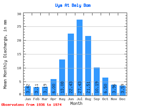
| Statistic | Jan | Feb | Mar | Apr | May | Jun | Jul | Aug | Sep | Oct | Nov | Dec | Annual |
|---|---|---|---|---|---|---|---|---|---|---|---|---|---|
| Mean | 3.42 | 3.14 | 3.19 | 6.00 | 13.08 | 22.43 | 27.43 | 21.51 | 10.20 | 6.50 | 3.96 | 3.59 | 121.49 |
| Standard Deviation | 0.80 | 1.56 | 1.21 | 1.17 | 4.74 | 6.44 | 7.02 | 4.43 | 2.23 | 1.05 | 0.75 | 0.69 | 22.58 |
| Min | 1.97 | 1.01 | 1.09 | 4.18 | 4.64 | 8.54 | 14.22 | 11.62 | 6.23 | 4.99 | 3.02 | 2.53 | 71.14 |
| Max | 4.64 | 7.28 | 5.80 | 8.75 | 24.05 | 40.19 | 48.40 | 33.66 | 15.62 | 9.09 | 5.78 | 4.69 | 156.86 |
| Coefficient of Variation | 0.23 | 0.50 | 0.38 | 0.20 | 0.36 | 0.29 | 0.26 | 0.21 | 0.22 | 0.16 | 0.19 | 0.19 | 0.19 |
 Return to R-Arctic Net Home Page