|
|
|||||||||||||||||
| Point ID: 8421 | Downloads | Plots | Site Data | Code: 10080 |
|
|
|||||||||||||||||
| Download | |
|---|---|
| Site Descriptor Information | Site Time Series Data |
| Link to all available data | |
| View: | Time Series | All |
| Units: | m3/s |
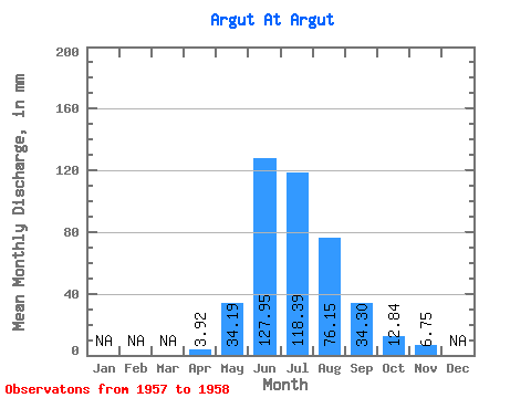
| Statistic | Jan | Feb | Mar | Apr | May | Jun | Jul | Aug | Sep | Oct | Nov | Dec | Annual |
|---|---|---|---|---|---|---|---|---|---|---|---|---|---|
| Mean | 3.92 | 34.19 | 127.95 | 118.37 | 76.14 | 34.30 | 12.84 | 6.75 | |||||
| Standard Deviation | 6.29 | 20.22 | 55.98 | 18.75 | 13.71 | ||||||||
| Min | 3.92 | 29.73 | 113.65 | 78.79 | 62.88 | 24.60 | 12.84 | 6.75 | |||||
| Max | 3.92 | 38.64 | 142.25 | 157.95 | 89.39 | 43.99 | 12.84 | 6.75 | |||||
| Coefficient of Variation | 0.18 | 0.16 | 0.47 | 0.25 | 0.40 |
 Return to R-Arctic Net Home Page