|
|
|||||||||||||||||
| Point ID: 8404 | Downloads | Plots | Site Data | Code: 9540 |
|
|
|||||||||||||||||
| Download | |
|---|---|
| Site Descriptor Information | Site Time Series Data |
| Link to all available data | |
| View: | Time Series | All |
| Units: | m3/s |
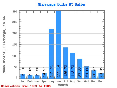
| Statistic | Jan | Feb | Mar | Apr | May | Jun | Jul | Aug | Sep | Oct | Nov | Dec | Annual |
|---|---|---|---|---|---|---|---|---|---|---|---|---|---|
| Mean | 19.19 | 16.04 | 15.28 | 24.57 | 219.29 | 299.13 | 136.70 | 113.72 | 87.21 | 54.66 | 36.37 | 24.44 | 1025.63 |
| Standard Deviation | 4.28 | 4.37 | 4.70 | 12.04 | 72.37 | 158.36 | 61.72 | 39.26 | 25.74 | 17.91 | 12.73 | 7.76 | 185.93 |
| Min | 12.42 | 8.59 | 7.63 | 10.86 | 89.47 | 108.75 | 56.40 | 45.03 | 49.96 | 0.00 | 19.55 | 14.51 | 691.29 |
| Max | 29.77 | 25.76 | 28.28 | 51.55 | 368.04 | 722.57 | 308.19 | 195.99 | 146.25 | 89.62 | 78.05 | 52.21 | 1305.30 |
| Coefficient of Variation | 0.22 | 0.27 | 0.31 | 0.49 | 0.33 | 0.53 | 0.45 | 0.34 | 0.29 | 0.33 | 0.35 | 0.32 | 0.18 |
 Return to R-Arctic Net Home Page