|
|
|||||||||||||||||
| Point ID: 8401 | Downloads | Plots | Site Data | Code: 9522 |
|
|
|||||||||||||||||
| Download | |
|---|---|
| Site Descriptor Information | Site Time Series Data |
| Link to all available data | |
| View: | Time Series | All |
| Units: | m3/s |
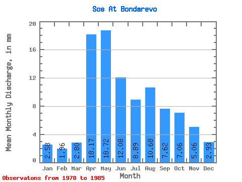
| Statistic | Jan | Feb | Mar | Apr | May | Jun | Jul | Aug | Sep | Oct | Nov | Dec | Annual |
|---|---|---|---|---|---|---|---|---|---|---|---|---|---|
| Mean | 2.60 | 1.99 | 2.80 | 18.17 | 18.72 | 12.07 | 8.87 | 10.67 | 7.62 | 7.07 | 5.06 | 2.94 | 98.99 |
| Standard Deviation | 0.77 | 0.75 | 1.96 | 8.20 | 7.69 | 5.99 | 5.69 | 7.72 | 3.63 | 2.35 | 2.21 | 1.05 | 22.23 |
| Min | 1.70 | 0.86 | 0.69 | 8.54 | 6.93 | 3.96 | 3.15 | 3.15 | 3.66 | 4.41 | 2.35 | 1.51 | 66.21 |
| Max | 3.78 | 3.16 | 6.93 | 31.10 | 28.67 | 23.18 | 21.14 | 24.57 | 15.25 | 11.66 | 9.76 | 4.41 | 130.94 |
| Coefficient of Variation | 0.29 | 0.38 | 0.70 | 0.45 | 0.41 | 0.50 | 0.64 | 0.72 | 0.48 | 0.33 | 0.44 | 0.36 | 0.23 |
 Return to R-Arctic Net Home Page