|
|
|||||||||||||||||
| Point ID: 8396 | Downloads | Plots | Site Data | Code: 9505 |
|
|
|||||||||||||||||
| Download | |
|---|---|
| Site Descriptor Information | Site Time Series Data |
| Link to all available data | |
| View: | Time Series | All |
| Units: | m3/s |
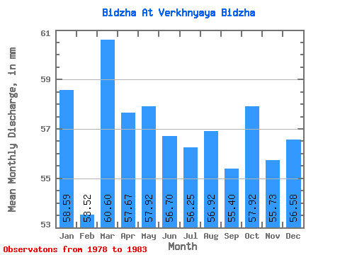
| Statistic | Jan | Feb | Mar | Apr | May | Jun | Jul | Aug | Sep | Oct | Nov | Dec | Annual |
|---|---|---|---|---|---|---|---|---|---|---|---|---|---|
| Mean | 58.58 | 53.98 | 60.59 | 57.67 | 57.91 | 56.70 | 56.24 | 56.91 | 55.40 | 57.91 | 55.73 | 56.57 | 673.53 |
| Standard Deviation | 5.16 | 5.56 | 5.60 | 4.67 | 5.50 | 5.37 | 2.80 | 2.65 | 2.11 | 3.26 | 3.73 | 3.63 | 37.01 |
| Min | 51.89 | 47.27 | 53.56 | 51.84 | 53.56 | 51.84 | 53.56 | 53.56 | 51.84 | 53.56 | 51.84 | 53.56 | 627.91 |
| Max | 63.60 | 61.00 | 66.95 | 64.80 | 66.95 | 64.80 | 60.26 | 60.26 | 56.70 | 61.93 | 59.94 | 61.93 | 718.32 |
| Coefficient of Variation | 0.09 | 0.10 | 0.09 | 0.08 | 0.10 | 0.10 | 0.05 | 0.05 | 0.04 | 0.06 | 0.07 | 0.06 | 0.06 |
 Return to R-Arctic Net Home Page