|
|
|||||||||||||||||
| Point ID: 8378 | Downloads | Plots | Site Data | Code: 9459 |
|
|
|||||||||||||||||
| Download | |
|---|---|
| Site Descriptor Information | Site Time Series Data |
| Link to all available data | |
| View: | Time Series | All |
| Units: | m3/s |
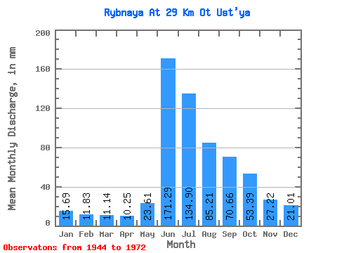
| Statistic | Jan | Feb | Mar | Apr | May | Jun | Jul | Aug | Sep | Oct | Nov | Dec | Annual |
|---|---|---|---|---|---|---|---|---|---|---|---|---|---|
| Mean | 15.69 | 11.93 | 11.13 | 10.24 | 23.61 | 171.29 | 134.88 | 85.20 | 70.66 | 53.39 | 27.23 | 21.00 | 632.21 |
| Standard Deviation | 3.35 | 2.62 | 2.48 | 2.48 | 14.31 | 39.78 | 28.27 | 22.85 | 17.64 | 15.03 | 6.70 | 4.70 | 87.89 |
| Min | 9.77 | 8.54 | 7.64 | 7.10 | 7.64 | 67.15 | 80.43 | 50.82 | 51.33 | 33.28 | 15.83 | 13.26 | 462.81 |
| Max | 21.74 | 17.23 | 16.39 | 15.74 | 59.22 | 230.12 | 179.86 | 142.74 | 118.48 | 87.94 | 39.44 | 30.40 | 799.94 |
| Coefficient of Variation | 0.21 | 0.22 | 0.22 | 0.24 | 0.61 | 0.23 | 0.21 | 0.27 | 0.25 | 0.28 | 0.25 | 0.22 | 0.14 |
 Return to R-Arctic Net Home Page