|
|
|||||||||||||||||
| Point ID: 8374 | Downloads | Plots | Site Data | Code: 9436 |
|
|
|||||||||||||||||
| Download | |
|---|---|
| Site Descriptor Information | Site Time Series Data |
| Link to all available data | |
| View: | Time Series | All |
| Units: | m3/s |
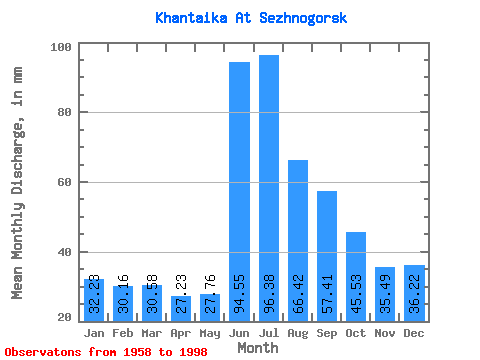
| Statistic | Jan | Feb | Mar | Apr | May | Jun | Jul | Aug | Sep | Oct | Nov | Dec | Annual |
|---|---|---|---|---|---|---|---|---|---|---|---|---|---|
| Mean | 32.22 | 30.42 | 30.57 | 27.23 | 27.76 | 94.55 | 96.37 | 66.41 | 57.41 | 45.52 | 35.49 | 36.22 | 583.74 |
| Standard Deviation | 24.10 | 24.37 | 24.90 | 22.22 | 17.42 | 86.06 | 70.10 | 30.84 | 17.96 | 14.48 | 20.79 | 23.35 | 116.11 |
| Min | 3.28 | 1.61 | 1.09 | 0.94 | 3.34 | 21.99 | 11.00 | 19.48 | 28.10 | 14.25 | 10.47 | 6.06 | 292.51 |
| Max | 70.24 | 75.91 | 79.80 | 61.62 | 60.23 | 267.06 | 302.97 | 165.91 | 103.86 | 73.40 | 78.46 | 77.72 | 873.21 |
| Coefficient of Variation | 0.75 | 0.80 | 0.81 | 0.82 | 0.63 | 0.91 | 0.73 | 0.46 | 0.31 | 0.32 | 0.59 | 0.65 | 0.20 |
 Return to R-Arctic Net Home Page